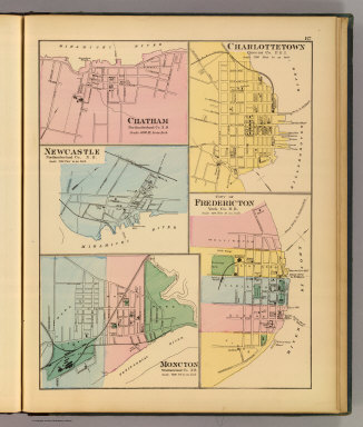
Detail View: David Rumsey Historical Map Collection: Charlottetown, Fredericton, Moncton.
|
Author:
|
Roe Brothers (Firm)
|
|
Date:
|
1878
|
|
Short Title:
|
Charlottetown, Fredericton, Moncton.
|
|
Publisher:
|
Roe Brothers
|
|
Publisher Location:
|
St. John
|
|
Type:
|
Atlas Map
|
|
Obj Height cm:
|
36
|
|
Obj Width cm:
|
28
|
|
Scale 1:
|
14,400
|
|
Note:
|
Three hand colored maps with 2 insets. Show wards, major buildings, railroads, etc.
|
|
State/Province:
|
New Brunswick
|
|
State/Province:
|
Prince Edward Island
|
|
City:
|
Charlottetown (P.E.I.)
|
|
City:
|
Fredericton (N.B.)
|
|
Full Title:
|
Charlottetown, Queens Co., P.E.I. City of Fredericton, York Co., N.B. Moncton, Westmorland Co., N.B. (with) Newcastle, Cumberland Co., N.B. (with) Chatham, Northumberland Co., N.B. (Drawn on the Rectangular polyconic projection. Drawn and published by Roe Brothers, (A.D. & W.B. Roe). Eng. by Worley & Bracher, Philada. Printed by F. Bourquin, Philada. 1878)
|
|
List No:
|
0859.032
|
|
Page No:
|
87
|
|
Series No:
|
35
|
|
Engraver or Printer:
|
Bourquin, F. (Frederick), b. 1808
|
|
Engraver or Printer:
|
Worley & Bracher
|
|
Publication Author:
|
Roe Brothers (Firm)
|
|
Pub Date:
|
1878
|
|
Pub Title:
|
Atlas of the Maritime Provinces of the Dominion of Canada, with historical and geological descriptions. Drawn on the Rectangular polyconic projection, from the British Admiralty charts, the National Boundary Survey, official plans, railway surveys, latest and most reliable maps, and new surveys made by the authors. Drawn and published by Roe Brothers, (A.D. & W.B. Roe). St. John, N.B. 1878. Eng. by Worley & Bracher, 27 South Sixth Street, Philada. Printed by F. Bourquin, 31 South Sixth St., Philada.
|
|
Pub Reference:
|
P10358; Library and Archives Canada.
|
|
Pub Note:
|
See note field above.
|
|
Pub List No:
|
0859.000
|
|
Pub Type:
|
State Atlas
|
|
Pub Maps:
|
35
|
|
Pub Height cm:
|
41
|
|
Pub Width cm:
|
34
|
|
Image No:
|
0859032
|
|
Download 1:
|
|
|
Download 2:
|
|
|
Authors:
|
Roe Brothers (Firm)
|
|
Collection:
|
Rumsey Collection
|