Detail View: David Rumsey Historical Map Collection: Carte des embouchures du Rhone
|
Author:
|
Minard, Charles Joseph, 1781-1870
|
|
Date:
|
1852
|
|
Short Title:
|
Carte des embouchures du Rhone
|
|
Publisher:
|
E.Thunot and Co.
|
|
Publisher Location:
|
Paris
|
|
Type:
|
Book Map
|
|
Obj Height cm:
|
28
|
|
Obj Width cm:
|
46
|
|
Scale 1:
|
20,000
|
|
Note:
|
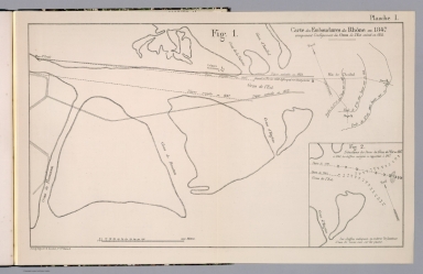
2 maps on 1 folded sheet of the mouths and shores of the Rhone river delta. Showing geomorphological transformations of the mouths of the Rhone. Depth shown by isolines and soundings.
|
|
Region:
|
Rhone River (Switzerland and France)
|
|
Subject:
|
Navigation
|
|
Full Title:
|
Carte des embouchures du Rhone, en 1847 : comprenant l'endiguement du gram de l'est execte en 1852. (with) Situation des passes du Grau de l'Est en 1847. et 1849. Autog. Regnier & Dourdet. (to accompany) Des embouchures des rivieres navigables. Par M. Minard. Paris. Imprime par E.Thuunot e Co. rue Bacine, 26.
|
|
List No:
|
13083.004
|
|
Page No:
|
Planche I
|
|
Series No:
|
4
|
|
Engraver or Printer:
|
Regnier et Dourdet
|
|
Publication Author:
|
Minard, Charles Joseph, 1781-1870
|
|
Pub Date:
|
1864
|
|
Pub Title:
|
Des embouchures des rivieres navigables. Par M. Minard. Paris. Imprime par E.Thuunot e Co. rue Bacine, 26.
|
|
Pub Note:
|
Minard's study of the changes to the mouths of the navigable and important commercial waterways of France. In 28 pages of text and 6 plates. Title page includes introductory text. Bound in green marbled paper-covered boards with title " Minard. Embouchures des rivieres navigables" in gilt on spine.
|
|
Pub List No:
|
13083.000
|
|
Pub Type:
|
Survey Book
|
|
Pub Maps:
|
6
|
|
Pub Height cm:
|
32
|
|
Pub Width cm:
|
27
|
|
Image No:
|
13083004.jp2
|
|
Download 1:
|
|
|
Download 2:
|
|
|
Authors:
|
Minard, Charles Joseph, 1781-1870
|