COLLECTION NAME:
David Rumsey Historical Map Collection
Record
Author:
Everts & Co.
Date:
1885
Short Title:
Frontier, Gosper, Red Willow, Furnas Cos.
Publisher:
Everts & Kirk
Publisher Location:
Philadelphia
Type:
Atlas Map
Obj Height cm:
71
Obj Width cm:
41
Scale 1:
211,200
Note:
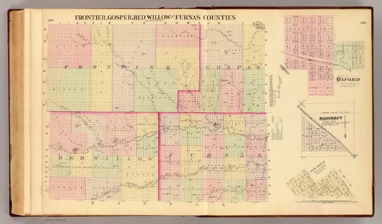
Lithographed map with 3 insets. Hand colored. Shows townships, sections, quarter sections, proposed railroad, roads, school districts, post offices, etc.
State/Province:
Nebraska
County:
Frontier County (Neb.)
County:
Red Willow County (Neb.)
City:
Bancroft (Neb.)
City:
Oxford (Neb.)
Full Title:
Frontier, Gosper, Red Willow and Furnas counties. (with) Oxford, Furnas & Harlan Cos. (with) Bancroft, Cuming County. (with) Rock Creek, Cuming Co., Neb. (Philadelphia, Everts & Kirk, 1885)
List No:
2719.189
Page No:
204-05
Series No:
193
Publication Author:
Everts & Kirk
Pub Date:
1885
Pub Title:
The official state atlas of Nebraska. Compiled from government surveys, county records and personal investigations. Philadelphia, Everts & Kirk, 1885. (on verso) Copyright, 1885, Everts & Kirk.
Pub Reference:
Checklist of printed maps of the Middle West to 1900, 12-0566; Phillips, 2107; LeGear. Atlases of the United States, 2184; Phillips. Maps of America, p. 461.
Pub Note:
See note field above.
Pub List No:
2719.000
Pub Type:
State Atlas
Pub Maps:
163
Pub Height cm:
45
Pub Width cm:
38
Image No:
2719189
Authors:
Everts & Co.
Collection:
Rumsey Collection
Link To Source

Frontier, Gosper, Red Willow, Furnas Cos.