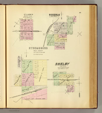
Detail View: David Rumsey Historical Map Collection: Stromsburg.
|
Author:
|
Everts & Kirk
|
|
Date:
|
1885
|
|
Short Title:
|
Stromsburg.
|
|
Publisher:
|
Everts & Kirk
|
|
Publisher Location:
|
Philadelphia
|
|
Type:
|
Atlas Map
|
|
Obj Height cm:
|
40
|
|
Obj Width cm:
|
32
|
|
Scale 1:
|
7,200
|
|
Note:
|
Lithographed map with 3 insets. Hand colored. Shows tracts, block and lot numbers, major buildings, railroad, etc.
|
|
State/Province:
|
Nebraska
|
|
City:
|
Osceola (Neb.)
|
|
City:
|
Stromsburg (Neb.)
|
|
Full Title:
|
Stromsburg, Polk County. (with) Clarks, Merrick County. (with) Osceola, Polk County. (with) Shelby, Polk County. (Philadelphia, Everts & Kirk, 1885)
|
|
List No:
|
2719.077
|
|
Page No:
|
89
|
|
Series No:
|
81
|
|
Publication Author:
|
Everts & Kirk
|
|
Pub Date:
|
1885
|
|
Pub Title:
|
The official state atlas of Nebraska. Compiled from government surveys, county records and personal investigations. Philadelphia, Everts & Kirk, 1885. (on verso) Copyright, 1885, Everts & Kirk.
|
|
Pub Reference:
|
Checklist of printed maps of the Middle West to 1900, 12-0566; Phillips, 2107; LeGear. Atlases of the United States, 2184; Phillips. Maps of America, p. 461.
|
|
Pub Note:
|
See note field above.
|
|
Pub List No:
|
2719.000
|
|
Pub Type:
|
State Atlas
|
|
Pub Maps:
|
163
|
|
Pub Height cm:
|
45
|
|
Pub Width cm:
|
38
|
|
Image No:
|
2719077
|
|
Download 1:
|
|
|
Download 2:
|
|
|
Authors:
|
Everts & Kirk
|
|
Collection:
|
Rumsey Collection
|