COLLECTION NAME:
David Rumsey Historical Map Collection
Record
Author:
Everts & Kirk
Date:
1885
Short Title:
Nebraska.
Publisher:
Everts & Kirk
Publisher Location:
Philadelphia
Type:
Atlas Map
Obj Height cm:
40
Obj Width cm:
82
Scale 1:
950,400
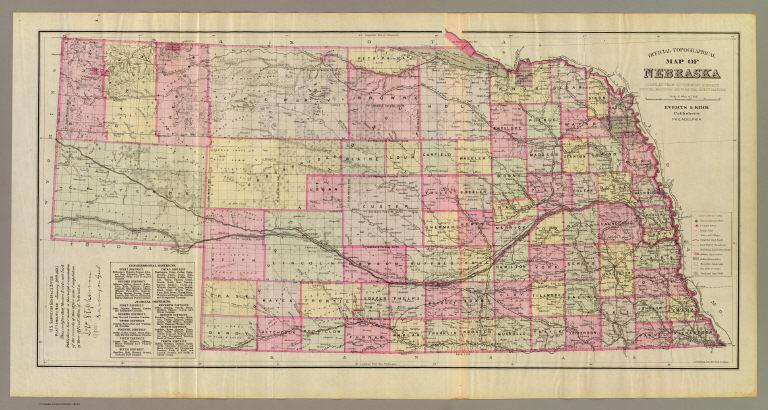
Note:
Lithographed map. Hand colored. Relief shown by hachures. Shows settlements, railroads, land district boundaries, rail road land grant limits, military and Indian reservations, etc. Prime meridians: Greenwich and Washington. Includes note of certification with facsimile signature "D V Stephenson, Surveyor Genl" U.S. Surveyor General's Office, Plattsmouth, Neb., January 20th, 1885. Includes index to congressional and judicial districts.
Reference:
Checklist of printed maps of the Middle West to 1900, 12-0557.
State/Province:
Nebraska
Full Title:
Official topographical map of Nebraska. Compiled from government surveys, official records and personal investigations. Everts & Kirk, publishers, Philadelphia. J.H. Kaefring Lith., 831 Arch St., Phila. (1885)
List No:
2719.001
Page No:
before 7
Series No:
5
Engraver or Printer:
Kaefring, J. H.
Publication Author:
Everts & Kirk
Pub Date:
1885
Pub Title:
The official state atlas of Nebraska. Compiled from government surveys, county records and personal investigations. Philadelphia, Everts & Kirk, 1885. (on verso) Copyright, 1885, Everts & Kirk.
Pub Reference:
Checklist of printed maps of the Middle West to 1900, 12-0566; Phillips, 2107; LeGear. Atlases of the United States, 2184; Phillips. Maps of America, p. 461.
Pub Note:
See note field above.
Pub List No:
2719.000
Pub Type:
State Atlas
Pub Maps:
163
Pub Height cm:
45
Pub Width cm:
38
Image No:
2719001
Authors:
Everts & Kirk
Collection:
Rumsey Collection
Link To Source

Nebraska.