COLLECTION NAME:
David Rumsey Historical Map Collection
Record
Author:
Barnes, Carroll
Date:
1946
Short Title:
The Valley, Yosemite National Park
Publisher:
Willy Nilly Map Co.
Publisher Location:
United States
Type:
Separate Map
Obj Height cm:
44
Obj Width cm:
56
Scale 1:
None shown
Note:
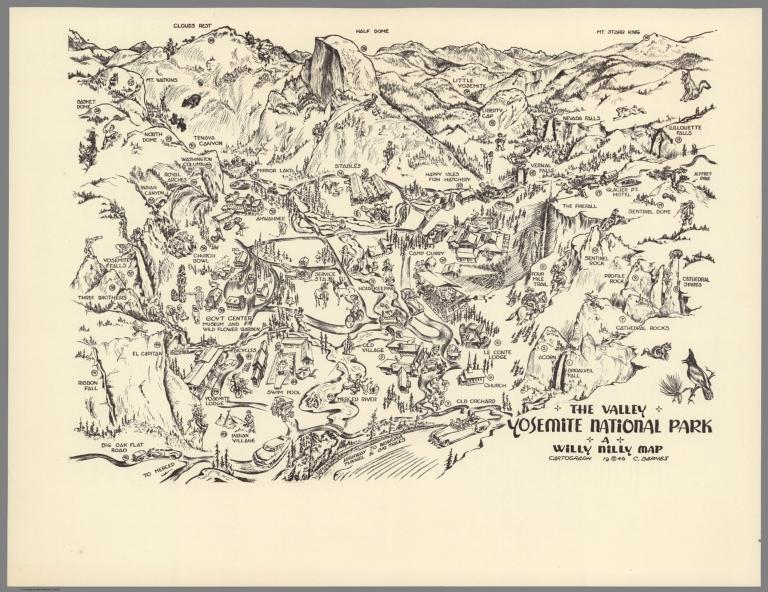
A whimsical 1946 pictorial map of the Yosemite National Park, California. Made to be fold twice and sent through the mail. When folded the map can be addressed, stamped and sent a through the mail. Map showing several landmarks and places of interest, including Half Dome, Clouds Rest, Little Yosemite, Indian Village, wildlife, recreational facilities, roads and trails. The reverse side of the map is printed with a Boasting Chart of 47 places and things to do and see corresponding to numbers on the map and a map of the High Sierra country surrounding the Yosemite Valley, with 35 corresponding to numbers on the map.
State/Province:
California
Region:
Yosemite National Park
Subject:
Pictorial map
Subject:
National Parks
Full Title:
The Valley, Yosemite National Park. A Willy Nilly Map. Cartograph 1946. C. Brarnes. (on verso) This High Sierra country surrounds Yosemite Valley. (with) Yosemite Valley Boasting chart.
List No:
11256.002
Series No:
2
Publication Author:
Barnes, Carroll
Pub Date:
1946
Pub Title:
The Valley, Yosemite National Park. A Willy Nilly Map. Cartograph 1946. C. Brarnes. (On verso) This High Sierra country surrounds Yosemite Valley. (with) Yosemite Valley Boasting chart.
Pub Note:
See note field above.
Pub List No:
11256.000
Pub Type:
Separate Map
Pub Height cm:
31
Pub Width cm:
42
Image No:
11256002.jp2
Authors:
Barnes, Carroll
Link To Source

The Valley, Yosemite National Park