COLLECTION NAME:
David Rumsey Historical Map Collection
Record
Author:
Patsis, H.
Date:
1960
Short Title:
Triplos chartes tes Aphrike, geophisikos, paragogikos, politikos
Publisher:
H. Patsis
Publisher Location:
Athene
Type:
Separate Map
Obj Height cm:
67
Obj Width cm:
95
Scale 1:
20,000,000
Note:
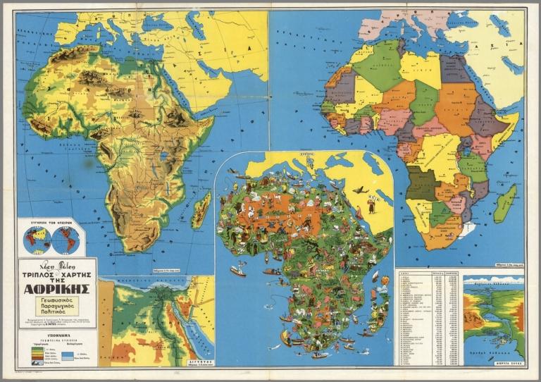
School triple map of Africa; political, geophysical, productive. Insets: Egypt, Suez Canal, and double hemispheres. Date estimated. Shows political divisions, geophysical features and products. Pictorial map shows agriculture, forests, domestic and wild life, as well as points of interest, people fishing, swimming, etc. Relief shown by shadings and spot heights. Includes index and notes.
World Area:
Africa
Subject:
Pictorial map
Subject:
School
Full Title:
Triplos chartes tes Aphrike, geophisikos, paragogikos, politikos. Copyright by H. Patsis - Athene. (3 insets) .
List No:
8267.000
Publication Author:
Patsis, H.
Pub Date:
1960
Pub Title:
Triplos chartes tes Aphrike, geophisikos, paragogikos, politikos. Copyright by H. Patsis - Athene. (3 insets) .
Pub Note:
See note field above.
Pub List No:
8267.000
Pub Type:
Separate Map
Pub Height cm:
67
Pub Width cm:
95
Image No:
8267000.jp2
Authors:
Patsis, H.
Link To Source

Triplos chartes tes Aphrike, geophisikos, paragogikos, politikos