Detail View: David Rumsey Historical Map Collection: Geological Map of New Jersey
|
Author:
|
Rogers, Henry Darwin
|
|
Date:
|
1839
|
|
Short Title:
|
Geological Map of New Jersey
|
|
Publisher:
|
P.S. Duval litho.
|
|
Publisher Location:
|
Philadelphia
|
|
Type:
|
Separate Map
|
|
Obj Height cm:
|
70
|
|
Obj Width cm:
|
40
|
|
Scale 1:
|
380,160
|
|
Note:
|
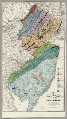
Marcou lists this as the first Geological map of New Jersey. Accompanies Rogers' "Description of the geology of the State of New Jersey, being a final report," Philadelphia, 1840. Report not present here. Rodgers used the Gordon/Tanner map as a base. Full color by geological formation. Relief shown by hachures.
|
|
Reference:
|
Marcou 236; Snyder p104.
|
|
State/Province:
|
New Jersey
|
|
Subject:
|
Geology
|
|
Full Title:
|
A Geological Map of New Jersey, by Henry D. Rogers, Prof. of Geology in Univ. of Penna. (To accompany the Report on the Geology of N. Jersey,) Jan. 1839. P.S. Duval, Lith. Philada. On Stone by J. Probst.
|
|
List No:
|
3346.000
|
|
Series No:
|
1
|
|
Engraver or Printer:
|
Probst, J.
|
|
Publication Author:
|
Rogers, Henry Darwin
|
|
Pub Date:
|
1839
|
|
Pub Title:
|
A Geological Map of New Jersey, by Henry D. Rogers, Prof. of Geology in Univ. of Penna. (To accompany the Report on the Geology of N. Jersey,) Jan. 1839. P.S. Duval, Lith. Philada. On Stone by J. Probst.
|
|
Pub Reference:
|
Marcou 236; Snyder p104.
|
|
Pub Note:
|
Marcou lists this as the first Geological map of New Jersey. Accompanies Rogers' "Description of the geology of the State of New Jersey, being a final report," Philadelphia, 1840. Report not present here. Rodgers used the Gordon/Tanner map as a base. Full color by geological formation.
|
|
Pub List No:
|
3346.000
|
|
Pub Type:
|
Separate Map
|
|
Pub Height cm:
|
70
|
|
Pub Width cm:
|
40
|
|
Image No:
|
3346000
|
|
Download 1:
|
|
|
Download 2:
|
|
|
Authors:
|
Rogers, Henry Darwin
|