Detail View: David Rumsey Historical Map Collection: Maine, New Hampshire and Vermont
|
Author:
|
Finley, Anthony
|
|
Date:
|
1827
|
|
Short Title:
|
Maine, New Hampshire and Vermont
|
|
Publisher:
|
Anthony Finley
|
|
Publisher Location:
|
Philadelphia
|
|
Type:
|
Pocket Map
|
|
Obj Height cm:
|
43
|
|
Obj Width cm:
|
54
|
|
Scale 1:
|
1,051,780
|
|
Note:
|
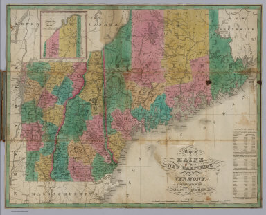
From the same plate as used in Finley's American Atlas 1826; date is estimated from the atlas. This map has the signature of Jon. Mason and the price of $1.00; see the New York map by Finley, also (1827), for the same owner's signature and price. Folded into brown leather covers 15x9 with "Maine New-Hampshire & Vermont" in gilt. Full color. Prime meridians are Washington D.C. and Greenwich.
|
|
Reference:
|
P-Maps p. 384.
|
|
State/Province:
|
Maine
|
|
State/Province:
|
New Hampshire
|
|
State/Province:
|
Vermont
|
|
Full Title:
|
Map of Maine, New Hampshire and Vermont, Compiled From The Latest Authorities. (inset) North Part of Maine.
|
|
List No:
|
2947.002
|
|
Series No:
|
2
|
|
Publication Author:
|
Finley, Anthony
|
|
Pub Date:
|
1827
|
|
Pub Title:
|
(Covers to) Map of Maine, New Hampshire and Vermont, Compiled From The Latest Authorities. (inset) North Part of Maine.
|
|
Pub Reference:
|
P-Maps p. 384.
|
|
Pub Note:
|
See note field above.
|
|
Pub List No:
|
2947.000
|
|
Pub Type:
|
Pocket Map
|
|
Pub Height cm:
|
15
|
|
Pub Width cm:
|
9
|
|
Image No:
|
2947002
|
|
Download 1:
|
|
|
Download 2:
|
|
|
Authors:
|
Finley, Anthony
|