Detail View: David Rumsey Historical Map Collection: Map of Africa
|
Author:
|
Tanner, Henry S.
|
|
Date:
|
1848
|
|
Short Title:
|
Map of Africa
|
|
Publisher:
|
Henry S. Tanner
|
|
Publisher Location:
|
Philadelphia
|
|
Type:
|
Wall Map
|
|
Obj Height cm:
|
104
|
|
Obj Width cm:
|
132
|
|
Scale 1:
|
7,000,000
|
|
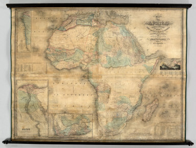
Note:
|
Large map of Africa with three inset maps: Egypt, Liberia, and Colony of the Cape of Good Hope. There is also an illustration of the "Comparative Heights of the Principal Mountains of Africa," as well as Statistical Tables. Interestingly, the copyright is by Anthony Finley, 1830. We assume that Tanner also issued similar sized wall maps of Europe, Asia, and Oceania. See our North America and South America.
|
|
World Area:
|
Africa
|
|
Full Title:
|
Map of Africa: Carefully Compiled From The Latest Maps & Charts And Other Geographical Publications. Philadelphia. Published By H.S. Tanner, 1848. Engraved By J.H. Young & E. Dankworth.
|
|
List No:
|
0986.000
|
|
Engraver or Printer:
|
Dankworth, Frederick, b. ca. 1804
|
|
Engraver or Printer:
|
Young, J. H. (James Hamilton)
|
|
Publication Author:
|
Tanner, Henry S.
|
|
Pub Date:
|
1848
|
|
Pub Title:
|
Map of Africa: Carefully Compiled From The Latest Maps & Charts And Other Geographical Publications. Philadelphia. Published By H.S. Tanner, 1848. Engraved By J.H. Young & E. Dankworth.
|
|
Pub Note:
|
See note field above.
|
|
Pub List No:
|
0986.000
|
|
Pub Type:
|
Wall Map
|
|
Pub Height cm:
|
104
|
|
Pub Width cm:
|
132
|
|
Image No:
|
0986000
|
|
Download 1:
|
|
|
Download 2:
|
|
|
Authors:
|
Tanner, Henry S.
|